HUM 493 / REL 493 - Intermediate Latin
Course Notes - Week 4
Cambridge Course
The photo on page 65 is of a mosaic in Tunis (North Africa) - the horses have no saddles. At the time of the Cambridge stories, the Romans were using saddle cloths or cushions. The fore-runner of the saddle as we know it today, with a rigid frame covered with leather (but no stirrups) was invented in China during the Han dynasty (206 BC - AD 220), and its use spread westwards until it reached Roman Gaul by about the time of our stories.
The stirrup was a later development - probably first used in India as a toe-stirrup in the 2nd century BC, and as a foot-stirrup by the Chinese in the 5th century AD. The foot-stirrup was adopted by the Muslim armies around 690AD, then by the Byzantine Empire, and then in Europe around 730 AD. In 730 AD Charles Martel realized the potential of the stirrup for increased effectiveness in mounted combat, and made his army adopt the new method of warfare - this was the start of the Frankish Empire and the start of the feudal system of knights in armor fighting on horseback.
The map on page 67 is of a portion of the "Peutinger Table" in the National Museum in Vienna. The Peutinger Table is a copy of a map of the whole Roman Empire, which the Emperor Augustus ordered Marcus Agrippa to make, mainly for military and administrative purposes. So towns, military camps, temples, bath-houses, taverns, roads, rivers, tribal territories, features of military importance, and the distances between them were more important than a strictly accurate representation of the geography. The original map took about 20 years to compile, and it was carved in marble on a wall near the Forum of Rome. Many copies of the map were made, for use by the military and provincial governors, and copies of copies continued to be made for centuries.
The Peutinger Table itself probably dates to the 13th century. It is in the form of a parchment roll, 22 ft. long and 13 inches wide, so that it could be rolled up and carried in the baggage on a journey.
Unfortunately, the most western section of the map, with most of Britain and the Iberian peninsula (Spain and Portugal) is lost. A small portion of South-East Britain is shown at the top left corner (looking at 90° to the page). The Mediterranean Sea is quite distorted - it is the dark band about two-thirds the way down.
Pages 80-81 show another section of the Peutinger Table - Rome is half-way down the left edge. Southern Italy stretches across page 80, with the Mediterranean (green) below and the Adriatic Sea above. Sicily is the triangular island tucked into the bend in the Italian coastline. Greece is the strange bulge to the right of Italy, and Africa and Egypt in the strip of land at the bottom.
The photographs on pages 76-77 show the remains of a Roman road in Yorkshire (N. England), and the better-preserved Via Appia in Italy.
A couple of the photographs on pages 79 and 80 show not only the sorts of carts which were used, but also typical Roman milestones (also page 84). Roman roads were marked at every Roman mile (1,000 paces, about 4,800 ft or 1.5 kilometers) by milestones which showed the distance to the start of the road and the name of the consul or Emperor under whom the road was built. The main roads (viae pūblicae, viae mīlitārēs) were built and maintained by the Roman state. The Emperor appointed commissioners (cūrātōrēs viārum) to look after the main roads. Smaller roads were built and maintained by local magistrates and land owners.
The Roman road system had an official starting position at the mīliārium aureum (Golden Milestone) - a column set up by Augustus in the Forum at Rome
Brogden Lane by Barnoldswick - aerial view
click on the photo for a larger picture
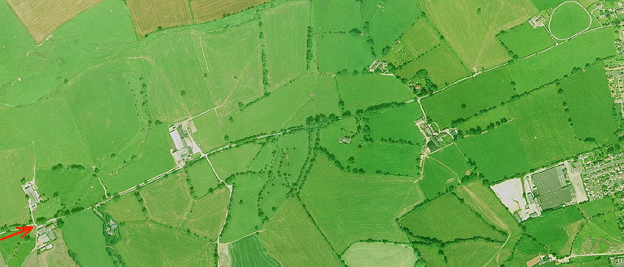
The town where I grew up, on the Yorkshire-Lancashire border, was beside a Roman road which ran East-West across the country. It is probably the road shown on the map on page 2, running from Deva (Chester) to Eboracum (York). Now it is only a minor country lane, with the remains of British hill-forts and earth-works on many of the hills overlooking the road. In some parts the Roman stones lie only about 12 inches below the modern surface, and where the modern surface ends at a group of farms (tip of the red arrow), the track of the Roman road continues in a straight line across a ford and fields. The next town, Colne, shows by its name that it was originally a Roman Colonia.
![]()
![]() Back to this Week's Assignment
Back to this Week's Assignment
![]()
Copyright © 1999 Shirley J. Rollinson, all Rights Reserved
![]()
![]()