Dr. Shirley's Web Courses
NASA Mirror Pages
These Pages are provided primarily for students at ENMU (Eastern New Mexico University) who are enrolled in the Course REL 433 - Biblical Archaeology, given by Dr. Shirley Rollinson. They may also be used as general resource material for students taking other courses on Old or New Testament subjects, or for anyone else interested in studying the Bible.
Some of my students have had difficulty accessing the photos on the NASA site, so these pages are provided as an alternative.
Greece
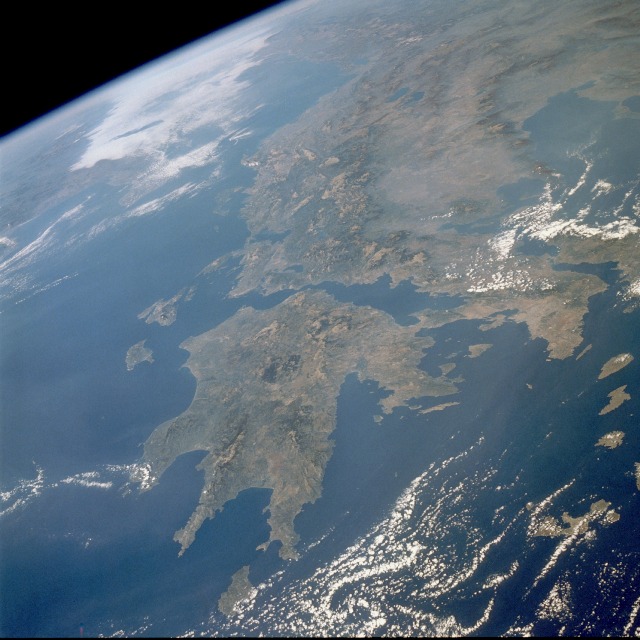
STS034-086-096 Greece October 1989
The terrain in this high-oblique, northwest-looking photograph is indicative of the rugged, mountainous landscape characterizing most of Greece.
Two major landform regions are captured in this photograph - the northwest-southeast-trending Pindos (Pindhos) Mountains in central Greece north of the Gulf of Corinth (Korinthiakós) and the Peloponnesus (Peloponnisos) Peninsula south of the Gulf of Corinth (center of the photograph).
The Pindos Mountains, a massive continuation of the Dinaric Alps of Albania and the former Yugoslavia, make the land inhospitable and travel difficult. This rugged terrain caused the Greeks to become a seafaring people, second only to the Norwegians in Europe.
The capital city of Athens (lighter area) is barely discernible along the southern edge of the broad peninsula near the eastern edge of the photograph.
The Peloponnesus Peninsula, connected to the mainland by the Isthmus of Corinth, has been likened to a hand with a thumb and three fingers.
The main part of the hand is Arcadia, the central mountainous area, which is a southeastward continuation of the Pindos Mountains.
Greece is flanked on the west by the Ionian Sea and on the east by the Aegean Sea.
![]()
![]()