Dr. Shirley's Web Courses
NASA Mirror Pages
These Pages are provided primarily for students at ENMU (Eastern New Mexico University) who are enrolled in the Course REL 433 - Biblical Archaeology, given by Dr. Shirley Rollinson. They may also be used as general resource material for students taking other courses on Old or New Testament subjects, or for anyone else interested in studying the Bible.
Some of my students have had difficulty accessing the photos on the NASA site, so these pages are provided as an alternative.
Israel - Haifa and the Galilee
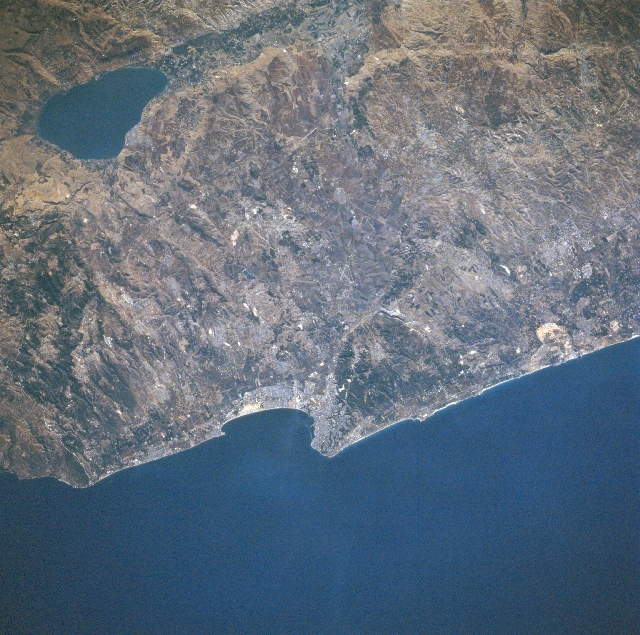
STS079-810-049 Haifa, Lake Tiberias (the Galilee), Israel September 1996
The third largest city in Israel, the coastal city of Haifa, situated midway between the center and bottom center of the image, is visible in this southeast-looking view. Haifa is the main port of Israel and is the country's industrial center as well. Major industries include oil refineries, food processing, shipbuilding, chemicals, electrical equipment, steel, and textiles.
In the upper left corner of the image, the pear-shaped freshwater Lake Tiberias (Sea of Galilee) can be seen. Lake Tiberias is 14 miles (23 km) long and has a maximum width of 8 miles (13 km). The lake has a maximum depth of 150 feet (46 meters) and covers an area of 64 square miles (165 square km). Lake Tiberias lies 680 feet (207 meters) below sea level and its bed forms part of the Dead Sea Rift Valley. At one time in the geologic past, Lake Tiberias was part of a great inland sea that extended from the Hula marshes in Northern Israel to a point 40 miles (64 km) south of the Dead Sea. The lake is completely encircled by beach, and bordered by escarpments and plains. Tourism and fishing are the main industries around the lake.
![]()
![]()