Dr. Shirley's Web Courses
NASA Mirror Pages
These Pages are provided primarily for students at ENMU (Eastern New Mexico University) who are enrolled in the Course REL 433 - Biblical Archaeology, given by Dr. Shirley Rollinson. They may also be used as general resource material for students taking other courses on Old or New Testament subjects, or for anyone else interested in studying the Bible.
Some of my students have had difficulty accessing the photos on the NASA site, so these pages are provided as an alternative.
Syria
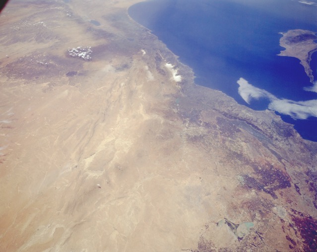
STS059-L06-077 Eastern Syria April 1994
Syria (the western third of the country included in this photograph) is an excellent example of a country where climate and topography dictate which regions of the country are developed.
The Mediterranean coastal area of Syria receives adequate rainfall; irrigation is not required. Toward the interior in the rain shadow, or leeward side of the mountains, agriculture is possible, but in many cases irrigation is required. The darker, brownish areas indicate subregions where land is being used for agriculture. Cotton and wheat are the two leading crops grown in the northwest corner of Syria.
Aleppo (Halab), a city of approximately 2 million located along an old caravan route, is barely visible near the northern edge of the photograph.
This region is the intersection of three major tectonic plates (African, Arabian, and Eurasian). Although the surface manifestation of these plate boundaries tends to be subtle, the boundaries can be seen from the Dead Sea Rift Valley along a line of low, northeast-southwest-trending mountain ridges through the desert area to the east.
The light brown area along the southeastern part of the photograph is the Syrian Desert. Many nomadic people graze their sheep, camels, and goats in this desert.
![]()
![]()