Geography Pages
Israel - Palestine
| PHYSICAL GEOGRAPHY | TOWNS |
|---|---|
 |
 |
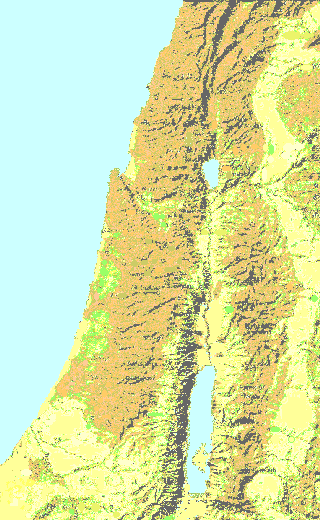
The maps show parts of Palestine, Syria, Lebanon, and the Hashemite Kingdom of Jordan, as well as Israel
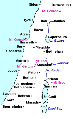
Damascus is the capital of Syria
Tyre and Sidon are in Lebanon (in ancient times called Phoenicia)
Banias (or Paneas), was also called Caesarea Philippi in New Testament times
The Caesarea on the Mediterranean coast was called Caesarea Maritima to distinguish it from the other towns dedicated to Caesar
Traditionally the territory of Israel stretched from Beer-sheba in the south, to Dan in the north. The saying "from Dan to Beersheba" meant the whole country
Lake Galilee is also known as Chinnereth, or Kinnereth, because it is shaped roughly like an old type of harp called a kinnor
Some maps show a small lake to the north of Galilee, called Lake Huleh.
Over the centuries this lake silted up and became a marsh infested with mosquitoes and malaria. It was drained in 1957, and was now used for agriculture and as a nature preserve
Go here to learn how to draw a map of Israel
Copyright © 1999 Shirley J. Rollinson, all Rights Reserved
![]()
![]()